The coast is not a fixed line on a map. It is a battlefield.
Every second of every day, waves are attacking rock, dragging sediment along the shore, and building new features somewhere else. The principle is simple: coasts change because the energy of the sea interacts with the resistance of the land. Understanding that interaction - the processes, the landforms they create, and the consequences for people - is the core of this IGCSE Geography topic.
Changing coastal environments is a favourite on Cambridge IGCSE Geography (0460) exam papers. Examiners consistently reward students who can trace a clear cause-and-effect chain from process to landform to human impact. That is exactly how this guide is structured.
Section 1: Physical Processes That Shape the Coast
Every coastal landform you will encounter in this topic exists because of three categories of process: erosion, transportation, and deposition. The logical starting point is the force that drives all of them: waves.
Waves: The Engine of Coastal Change
Waves form when wind blows across the surface of the ocean. The stronger the wind, the longer the fetch (the distance of open water the wind blows over), and the longer the wind blows, the larger the waves become. When waves approach shallow water near the coast, friction with the seabed causes them to slow down and increase in height until they break.
Two types of wave matter for your exam, and the distinction between them drives much of what follows.
| Feature | Constructive Waves | Destructive Waves |
|---|---|---|
| Wave height | Low | High |
| Wave frequency | Low (6-8 per minute) | High (10-14 per minute) |
| Swash vs backwash | Strong swash, weak backwash | Weak swash, strong backwash |
| Dominant process | Deposition | Erosion |
| Effect on beach | Builds up material, creates wide gentle beaches | Removes material, creates steep narrow beaches |
Why does this matter? Because the type of wave determines whether a stretch of coast is being built up or worn away. A coastline dominated by destructive waves will retreat over time. One dominated by constructive waves will grow. Most real coastlines experience both, depending on the season and weather conditions.
Wave Refraction
Waves rarely approach a coastline head-on. When a wave front reaches a headland, the part of the wave nearest the headland enters shallow water first and slows down, while the rest of the wave continues at its original speed. This bends the wave so that energy is concentrated on the headland and spread out across the bay. The result: headlands receive the most intense erosion, while bays receive calmer water and tend to accumulate sediment.
The Four Types of Coastal Erosion
Erosion is the wearing away of rock by natural forces. At the coast, four distinct processes operate, and examiners expect you to name and define all four precisely.
| Process | Definition | How It Works |
|---|---|---|
| Hydraulic action | The force of water compressing air in cracks | Waves crash into rock faces, forcing air into cracks at high pressure. Repeated compression and release weakens the rock until fragments break away. |
| Corrasion (abrasion) | Rocks and sediment thrown against the cliff face by waves | Waves pick up sand, pebbles, and boulders and hurl them at the cliff. This acts like sandpaper, grinding and chipping the rock surface. |
| Corrosion (solution) | Chemical dissolving of rock by seawater | Slightly acidic seawater dissolves soluble rocks such as limestone and chalk. This process works even on calm days. |
| Attrition | Rock fragments wearing each other down | Loose rocks and pebbles carried by waves collide with each other, gradually becoming smaller, smoother, and rounder. |
Transportation of Sediment
Once material has been eroded, it needs to go somewhere. The sea transports sediment in four ways: traction (large boulders rolling along the seabed), saltation (smaller pebbles bouncing along the seabed), suspension (fine particles like silt and clay carried within the water), and solution (dissolved minerals carried invisibly in the water).
Longshore Drift
Longshore drift is the process that moves sediment along the coast. It works like this: waves approach the shore at an angle (determined by the prevailing wind direction). The swash carries sediment up the beach at that angle. The backwash then drags sediment straight back down the beach under gravity. The net effect is a zig-zag movement of material along the shoreline.
Why does this matter? Longshore drift is the single most important process for explaining why beaches build up in some places and disappear from others. It also explains the formation of spits and bars, which we will cover shortly.
Deposition
Deposition occurs when the sea loses energy and drops its load of sediment. This happens in sheltered areas such as bays, behind headlands, and where the coastline changes direction. The larger, heavier particles (boulders and pebbles) are deposited first because they require the most energy to transport. Finer material like sand and silt is carried further before being deposited.
Section 2: The Main Landforms Associated With These Processes
Every landform at the coast is the product of either erosion, deposition, or both. The skill the examiner is testing is whether you can connect the process to the feature.
Discordant and Concordant Coastlines
Before examining individual landforms, understand the two broad coastal types that determine which landforms develop where.
A discordant coastline has alternating bands of hard and soft rock running perpendicular to the sea. The soft rock erodes faster, creating bays, while the hard rock resists and juts out as headlands. The Dorset coast in southern England is the classic example.
A concordant coastline has rock types running parallel to the sea. The outer band of resistant rock protects the softer rock behind it. If the outer rock is breached (by a fault or weakness), the sea can erode the softer rock behind rapidly, forming a cove. Lulworth Cove is the textbook case.
Erosional Landforms: The Cliff Retreat Sequence
The formation of cliffs, wave-cut platforms, caves, arches, stacks, and stumps follows a logical sequence. Each landform is a stage in the same process of cliff retreat, and examiners love asking you to trace this sequence from start to finish.
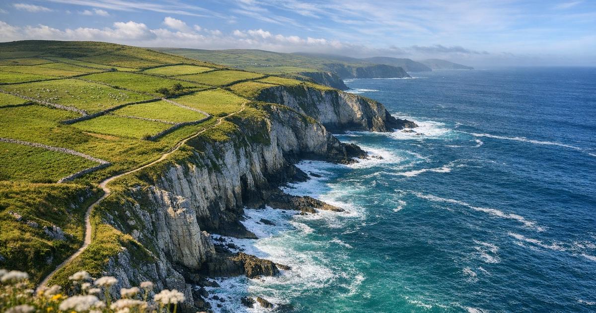
Cliffs and wave-cut platforms. Waves attack the base of the rock face, eroding a wave-cut notch through hydraulic action, corrasion, and corrosion. As the notch deepens, the rock above becomes unsupported and eventually collapses. The cliff retreats inland, leaving behind a gently sloping platform of rock at the base. This is the wave-cut platform, visible at low tide. The platform itself limits further erosion because waves must cross it before reaching the cliff, losing energy as they go.
Caves, arches, stacks, and stumps. Where a headland contains a line of weakness (a fault, joint, or softer rock), waves exploit it through hydraulic action and corrasion, hollowing out a cave. If the headland is narrow enough, caves eroded from both sides can meet in the middle, forming an arch. The roof of the arch is unsupported and weakened by weathering and wave erosion from below. Eventually it collapses, leaving an isolated column of rock: a stack. The stack is then undercut and eroded until it collapses to a low stump, often only visible at low tide.
Depositional Landforms
Beaches. Beaches form where constructive waves deposit more material than destructive waves remove. They accumulate in sheltered areas such as bays, where wave refraction spreads wave energy and reduces erosion. Beach material ranges from fine sand to large pebbles (shingle), and beaches often show a gradient: finer material near the water, coarser material higher up where storm waves deposit it.
Spits. A spit forms where longshore drift carries sediment past a change in the direction of the coastline, such as a river mouth or estuary. The sediment continues to be deposited in the direction of the prevailing drift, building outward into the open water. The end of the spit often curves inward (a recurved tip) due to secondary wave directions. Behind the spit, sheltered low-energy conditions allow mud flats and salt marshes to develop.
Bars. If a spit grows across the entire mouth of a bay, it becomes a bar, cutting off the bay from the open sea. The trapped water behind the bar forms a lagoon. Bars only form where there is no strong river current to prevent the spit from extending all the way across.
Sand dunes. Sand dunes form above the high-tide mark when wind blows dry sand inland from the beach. An obstacle (driftwood, seaweed, or vegetation) traps the sand, and as more sand accumulates, the dune grows. Vegetation plays a critical role: marram grass colonises the dunes first, its roots binding the sand and stabilising the dune. Over time, a succession of dune ridges develops, with the youngest (embryo dunes) nearest the sea and the oldest (fixed dunes) furthest inland. The older dunes have more soil, more humus, and more diverse plant communities.
Section 3: Coasts Present Opportunities and Hazards for People
The coast is not just a physical system. Millions of people live, work, and depend on coastal zones. This final section connects the physical geography to the human dimension, which is where the higher-mark questions often sit.
Opportunities of Coastal Areas
Coasts attract human settlement for several practical reasons:
- Tourism and recreation: beaches, scenery, and water sports generate significant income. Coastal resorts support hotels, restaurants, and service industries.
- Fishing: coastal waters and estuaries support commercial fishing industries and aquaculture.
- Ports and trade: natural harbours and river estuaries provide locations for ports, which are essential for international trade.
- Energy: offshore wind farms, tidal power, and wave power offer renewable energy potential. Oil and gas extraction also occurs offshore.
- Agriculture: coastal lowlands and deltas often have fertile alluvial soils.
- Biodiversity: coral reefs, mangroves, salt marshes, and estuaries are among the most productive ecosystems on the planet.
Hazards: Coastal Erosion
The same processes that create dramatic landforms also threaten human infrastructure. Coastal erosion is a hazard wherever people have built on or near retreating coastlines.
Causes of increased coastal erosion:
- Rising sea levels (thermal expansion of oceans and melting of ice sheets) increase the reach and power of waves.
- Stronger and more frequent storms generate larger destructive waves.
- Human interference with natural processes: groynes or sea walls in one location can starve a neighbouring stretch of coast of sediment, accelerating erosion there.
- Removal of natural defences such as mangroves, sand dunes, or coral reefs.
Effects of coastal erosion:
- Loss of homes, farmland, and infrastructure (roads, railways, utilities).
- Economic cost of damage and relocation.
- Loss of habitats for wildlife.
- Increased flood risk for low-lying areas behind the eroding coast.
Hazards: Coral Reef Degradation
Coral reefs are highly productive ecosystems, but they are also fragile. Degradation of coral reefs removes a natural coastal defence (reefs absorb wave energy) and destroys biodiversity.
Causes of coral reef degradation:
- Rising sea temperatures cause coral bleaching. Corals expel the symbiotic algae (zooxanthellae) that give them colour and nutrients. Prolonged bleaching kills the coral.
- Ocean acidification (caused by increased CO2 dissolving in seawater) reduces the ability of corals to build their calcium carbonate skeletons.
- Pollution from agricultural runoff (nutrients, pesticides) causes algal blooms that smother coral.
- Overfishing removes species that keep algae in check, disrupting the reef ecosystem.
- Physical damage from destructive fishing methods (dynamite fishing, cyanide fishing) and careless tourism (anchoring, trampling).
Hazards: Rising Sea Levels
Sea level rise is a slow-onset hazard with enormous consequences. Two mechanisms drive it:
- Thermal expansion: as ocean water warms, it expands in volume. This is currently the largest contributor to sea level rise.
- Melting of land-based ice: glaciers and ice sheets in Greenland and Antarctica are losing mass. When land-based ice melts and flows into the ocean, it adds water to the system. (Melting sea ice does not raise sea levels because it is already floating and displacing its own weight.)
Consequences of rising sea levels:
- Flooding of low-lying coastal areas and entire island nations (e.g., the Maldives, Tuvalu).
- Saltwater intrusion into freshwater aquifers, contaminating drinking water supplies.
- Increased coastal erosion as the baseline water level rises.
- Destruction of coastal wetlands, mangroves, and salt marshes.
- Displacement of populations: millions of environmental refugees could be forced to relocate.
Coastal Management Strategies
How do we protect coastlines? The approaches fall into two broad categories: hard engineering and soft engineering. Each has advantages and drawbacks, and examiners frequently ask you to evaluate them.
| Strategy | Type | How It Works | Limitations |
|---|---|---|---|
| Sea wall | Hard | A concrete or stone wall built along the coast to reflect wave energy | Expensive to build and maintain. Can cause increased erosion at the base due to wave reflection (scour). |
| Groynes | Hard | Wooden or rock barriers built perpendicular to the beach to trap sediment moved by longshore drift | Effective locally, but starve beaches further down the coast of sediment (terminal groyne syndrome). |
| Rock armour (rip-rap) | Hard | Large boulders placed at the foot of a cliff to absorb wave energy | Relatively cheap but can look unattractive. Boulders may shift over time. |
| Gabions | Hard | Wire cages filled with rocks, placed along the shore | Cheaper than sea walls but less durable. Wire cages corrode over time. |
| Beach nourishment | Soft | Pumping or dumping sand onto an eroding beach to replace lost material | Looks natural but must be repeated regularly. Can be expensive over time. |
| Dune stabilisation | Soft | Planting marram grass and fencing to encourage sand dune growth as a natural buffer | Low cost and sustainable, but slow to establish and vulnerable to storm damage. |
| Managed retreat | Soft | Allowing the sea to flood low-value land, creating new salt marshes that absorb wave energy | Politically controversial. Landowners may need compensation. Not suitable for high-value areas. |
| Mangrove restoration | Soft | Replanting mangrove forests along tropical coastlines to reduce wave energy and trap sediment | Only viable in tropical climates. Takes years to become effective. |
Worked Example: Explaining Spit Formation
Question: Explain how a spit is formed. [4 marks]
Model Answer:
Longshore drift transports sediment along the coastline in the direction of the prevailing wind (1 mark). Where the coastline changes direction, such as at a river estuary, sediment continues to be deposited in the original direction of drift, extending out into open water (1 mark). Over time, continued deposition lengthens the spit further. The end of the spit may curve inward due to wave action from a secondary direction, forming a recurved tip (1 mark). In the sheltered water behind the spit, low-energy conditions allow fine sediment to accumulate, and salt marsh vegetation colonises the area (1 mark).
Common Mistakes to Avoid
These errors appear repeatedly in student scripts, and each one costs marks:
- Confusing corrasion and corrosion. Corrasion is physical (rock thrown against rock). Corrosion is chemical (dissolving). They sound similar, but they describe completely different mechanisms. Using them interchangeably tells the examiner you do not understand the difference.
- Describing longshore drift without mentioning waves approaching at an angle. The angle of wave approach is the cause. Without it, there is no longshore drift. State the cause before you describe the effect.
- Saying "the sea erodes the cliff" without naming the specific process. Hydraulic action, corrasion, corrosion, or attrition? The mark scheme names them. You should too.
- Forgetting that wave-cut platforms limit further erosion. Students often describe cliff retreat as if it continues at a constant rate. The growing platform reduces the energy reaching the cliff, so erosion slows over time.
- Evaluating coastal management by listing only advantages. If the question says "evaluate" or "assess," you must give both sides. One-sided answers cannot access full marks.
- Ignoring the link between human activity and increased coastal hazards. Rising sea levels, reef degradation, and sediment starvation from groynes are all examples where human action makes the coast more dangerous. Examiners reward students who make these connections explicit.
Self-Check Questions
Attempt each of these in two or three sentences before revisiting the relevant section above.
- Compare constructive and destructive waves. Which type builds beaches, and why?
- Name and define the four types of coastal erosion.
- Explain how wave refraction concentrates erosion on headlands.
- Describe the sequence of landform formation from cliff to stump.
- Explain how longshore drift leads to the formation of a spit.
- What is the difference between a discordant and a concordant coastline?
- Give two causes and two effects of coral reef degradation.
- Compare one hard engineering strategy and one soft engineering strategy for coastal protection, including advantages and disadvantages of each.
Connecting the Three Sections
The power of this topic lies in the connections across its three sections. Physical processes create landforms. Landforms create opportunities (a sandy beach attracts tourists, a natural harbour supports a port). Those same processes also create hazards (cliff retreat destroys homes, longshore drift starves beaches of sediment). Human responses to those hazards - hard engineering, soft engineering, or managed retreat - then alter the physical processes themselves, sometimes solving one problem while creating another.
Tracing that full chain from process to landform to human impact to management response is what separates a competent answer from an excellent one in IGCSE Geography. The examiners are not simply asking what a wave-cut platform looks like. They want to know why it forms, how it affects the rate of cliff retreat, why that matters for people living on the clifftop, and what can be done about it.
Build that chain into every extended answer you write, and you will consistently reach the top of the mark range.

A thorough revision guide to Changing coastal environments for Cambridge IGCSE Geography (0460), covering physical processes of erosion and deposition, the landforms they produce, and the human opportunities and hazards associated with coastal areas.



Maoni